|
|
|
||||||||||||||||||
|
|||||||||||||||||||
|
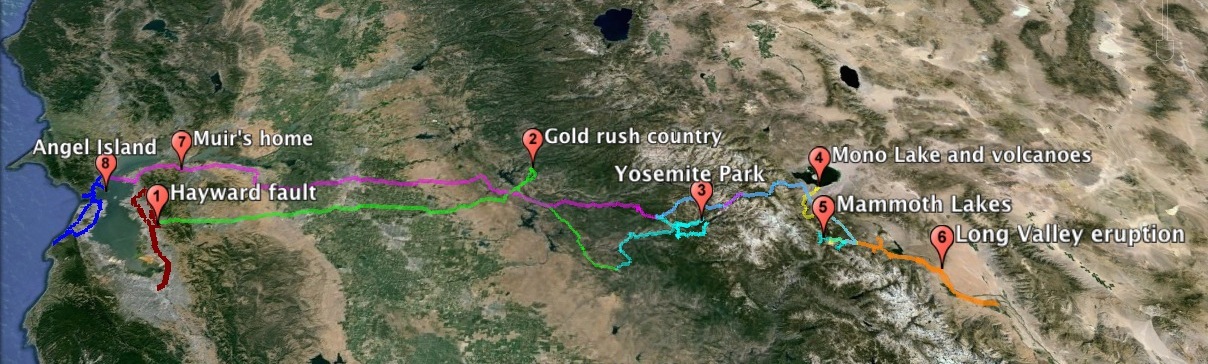
Geology on the Edge planned itinerary July 11-19 2015 |
|||||||||||||||||||
|
|
|||||||||||||||||||
|
|
|||||||||||||||||||
|
Driving: Instruction: |
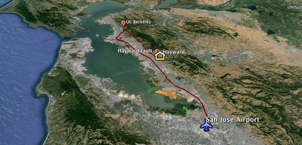
Our 9:25 AM flight from ATL
should put us in San Jose before noon. We will follow the Hayward fault, the fault in the Bay
area with the highest probability of a major quake, to UC Berkeley, with its stadium astride the Hayward fault.
It is the most recent of many buildings we will see on campus to be redesigned and rebuilt for improved earthquake readiness.
Returning to Hayward for the night, we will see cracked buildings and sidewalks, and a neighborhood built
atop a pressure ridge, all evidence of ongoing movement.
|
Questions: How are the faults recognized? How have they
shifted the landscape on various time scales? Why are both pull-apart and compressional features found along these faults? What damage have the faults done to
buildings? How is risk determined and responded to? |
|||||||||||||||||
|
|
|||||||||||||||||||
|
Driving: Instruction: |
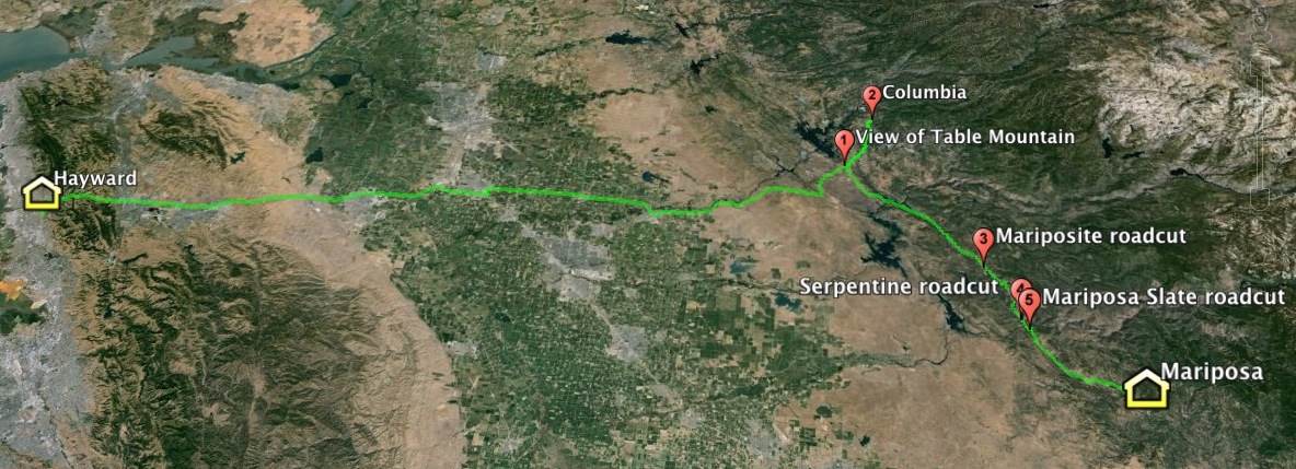
Cross California's Central
Valley, learning factors that made it one the world's most productive farming
areas. Visit the preserved gold rush town of Columbia, see rocks that tell the
geologic story behind California's gold deposits, and visit the California State Mining and
Mineral Museum in Mariposa. |
Questions: Why was the gold concentrated along a linear belt?
How did the uplift of the Sierra Nevada influence Central Valley and the gold
deposits? What impacts did the gold rush have on the landscape and on
American history? |
|||||||||||||||||
|
|
|||||||||||||||||||
|
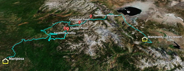
Driving: Instruction: Map. KMZ, Photos 1 & 2, 3, and 4 |
Begin at Yosemite Park's
Glacier Point for a view of the valley and Half Dome, then visit the foot of
Yosemite Falls. Continue into the high country where the ice sheet
originated, observing the debris and erosional trail that the ice left
behind. Leaving the park, descend the steep side of the Sierra Nevada to the
rain shadow desert, then continue to Mammoth Lakes where a break in the Mountains
interrupts the rain shadow. |
Questions: Can a pre-glacial history be read in this
landscape? Why was Whitney so sure Muir was wrong about the glacial origin?
How are the intrusive igneous rocks here similar to and different from Stone
Mountain, GA? What evidence have the glaciers left of their passage? |
|||||||||||||||||
|
Day 4: North from Mammoth Lakes (AM); Gondola on
Mammoth Mountain (PM) |
|||||||||||||||||||
|
Driving: 86 mi./ 2.6 hr. Instruction: 6 hr. |
|
||||||||||||||||||
|
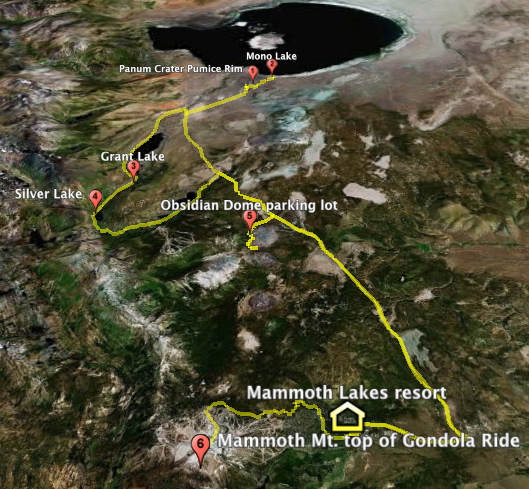
Make a short ascent of
Panum Crater, a volcano built of obsidian and pumice that last erupted 700
years ago. Nearby, examine tufa (calcite) towers formed by evaporation of Mono
Lake's waters. Signs describe the court decision forcing Los Angeles to slow
its diversion of waters feeding the lake to a renewable speed, saving the
lake. On the return leg, observe
how a fault scarp interacted with glaciation to produce a horseshoe-shaped
drainage as we pass LA's reservoir, Grant Lake, and Silver Lake. Then visit
the base of Obsidian Dome, formed when viscous magma oozed from a vent about
600 years ago. |
|||||||||||||||||||
|
After lunch, we take a
gondola ride up Mammoth Mountain, a favored ski resort because of a break in
the Sierra Nevada that lets Pacific moisture in as snow. It is also a volcano
that last exploded about 50,000 years ago. The gondola ride up the mountain
passes a vent that smells of sulfur, which killed three ski patrol staff in
2006 with dangerous levels of carbon dioxide gas. |
|||||||||||||||||||
|
Questions: Why is there both obsidian and pumice at Panum
Crater, but only obsidian at Obsidian Dome? How does tufa form and why are
the towers hollow? Is it a coincidence that some of the youngest volcanoes
are at Mono Lake? How did the locals prevail in saving the lake against the
powerful city? Could Mammoth
Mountain erupt without much warning? |
|||||||||||||||||||
|
|
|||||||||||||||||||
|
Driving: Instruction: |
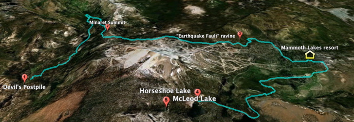
Devil's Postpile National Monument
is a classic location to see hexagonal columns of basalt up to 60 feet high.
Minaret Summit en route offers panoramic views. On the return we stop at
the misnamed "Earthquake Fault," a puzzling gash in the Earth.
After lunch we venture out to Horseshoe Lake, at the foot of Mammoth
Mountain, where volcanic CO2 has killed all the vegetation, and
take a short hike to the beautiful alpine McLeod Lake. |
Questions: Why does cooling magma break into neat hexagonal
columns? Why would a gash in the ground remain unfilled by debris? Why do
some volcanoes emit CO2? Is it enough to put signs in the area
warning hikers and skiers, or should it be off-limits? |
|||||||||||||||||
|
|
|||||||||||||||||||
|
Driving: Instruction: |
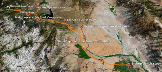
Long Valley Caldera, (with Yellowstone) one of two
active supervolcanoes in the contiguous 48 states, is related to a new pull-apart
plate boundary. We look at layers of the huge ash deposit expelled by the
eruption 760,000 years ago, see a gorge carved in that deposit by the Owens
River, visit Hot Creek at which earthquake episodes released scalding waters,
and climb an active fault scarp that cuts a young glacial deposit. |
Questions: If Long Valley Caldera had a similar eruption
today, what would the human consequences be? Have eruptions of this scale
happened in historical time? Why were the hot springs closed to bathers? Does
the hot water have economic value? Is there a relationship between the
faulting and the hot springs? |
|||||||||||||||||
|
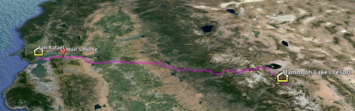
Itinerary Day 7:
Mammoth Lakes to San Rafael via John Muir National Historic Site |
|||||||||||||||||||
|
|
|||||||||||||||||||
|
Driving: Instruction: |
Our longest travel day will be dedicated to the man who founded the Sierra Club
and was the first to decipher the glacial origin of Yosemite Valley. En route across the Sierra and Great Valley,
there will be an opportunity to hear recordings by actor Lee Stetson of some of John Muir's incredible stories, such as a night
surviving a blizzard on Mt. Shasta, by huddling in a volcanic fumarole. Our one field stop will be at Muir's home in Martinez,
California. |
Questions: Does Muir deserve to be remembered as the "Father of our national parks"? Could he really have
ridden an avalanche with little injury, as he claimed? |
|||||||||||||||||
|
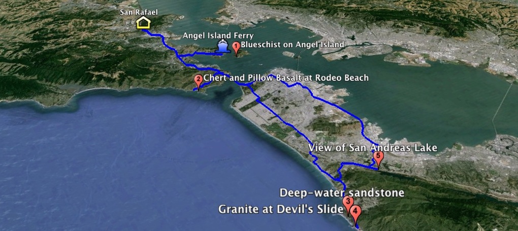
Itinerary Day 8: Colorful rocks from Angel Island to Devil's Slide |
|||||||||||||||||||
|
|
|||||||||||||||||||
|
Driving: Instruction: |
A short ferry ride takes us to car-free Angel Island,
for an optional hike to see unusual subduction-zone rocks (blueschists). Returning to land,
we drive to Rodeo Beach for red deep-sea chert resting on some of the best preserved pillow lavas on land.
Then we cross the Golden Gate Bridge and the San Andreas fault to spectacular Devil's Slide, until recently a
dangerous stretch of CA 1. Now bypassed by a tunnel, the walking trail reveals granite similar to Yosemite's,
possibly shifted here from near the southern end of the Sierra Nevada. The last stop of the day is San Andreas Lake,
nestled in a pull-apart valley made by the famous fault named after the lake.
|
Questions: Why is blueschist so rarely seen? What is pillow basalt and why is it often
associated with red chert? Is it risky to have dams astride the San Andreas fault, as
there are south of natural San Andreas Lake? |
|||||||||||||||||