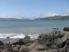
1. At Angel Island State Park in San Francisco Bay, you can explore remnants of the Pacific seafloor (serpentine and pillow basalt) and effects of its subduction under North America (blueschist).
2. Gold rush towns lie along the foothills of the Sierra Nevada, where you see a basalt lava flow that spilled down valleys, excavation due to gold mining, and the the Melones fault zone with remnants of Pacific seafloor.
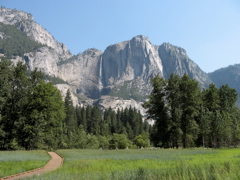
3. Yosemite Valley, carved into granitic rocks by a glacier, attracts millions of visitors to its lush floor and to sweeping views from the overlook at Glacier Point.
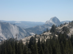
4. At Olmsted Point overlook, you can study many features typical of granitic rocks and movement of glacial ice, amid views that span from jewel-like Tenaya Lake to Half Dome.
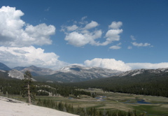
5. Tuolomne Meadows in Yosemite Park was at the center of a 2,000-foot thick icefield. At Pothole Dome, you see ice-related features carved in granitic rock. Farther east on Tioga Pass Road you see the oldest rocks of the park and descend the steep eastern slope of the Sierra.
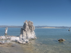
6. Mono Lake is an alkaline water body due to evaporation in a desert. At South Tufa Reserve area are tufa deposits made of calcium carbonate, left by precipitation around mineral-rich springs within the lake.
7. Volcanoes as young as a few hundred years old stretch from Mono Lake to the outskirts of Mammoth Lakes, related to the nearby Sierra Nevada fault zone that uplifted the steep eastern edge of the Sierra Nevada.
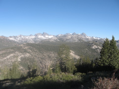
8. The area around the ski resort town of Mammoth Lakes has spectacular glacier-carved scenery (without Yosemite Valley's summer hordes of visitors).
9. The Long Valley supervolcano, in which the Mammoth Lakes resort lies, erupted 760,000 years ago, leaving a huge pit or caldera, and ejecting a thick pumice and ash deposit, the Bishop Tuff. The tuff underlies the Volcanic Tablelands, into which the Owens River has cut its gorge.
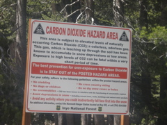
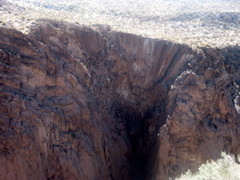
10. You can see evidence for continuing movement of the Sierra Nevada fault zone and continued existence of magma at the Long Valley supervolcano at several locations near the resort town of Mammoth Lakes.
H. The Hayward fault is given a higher probability than the San Andreas of being the site of the next "big one" earthquake for the Bay Area. Evidence of the fault can be toured in and around Hayward and northward through Berkeley.
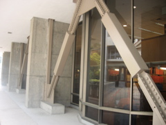
B. Buildings around the UC Berkeley Campus provide examples of state-of-the art preparations to safely resist major earthquakes, especially the horizontal accelerations for which most buildings are not designed. The Hayward fault runs through the east edge of the campus.